
Section 8: The Good, The Bad, And The Ugly
Rte 372, Plainville to Prattling Pond Road, Farmington, 6.3 miles
October 6, 2007
Updated with reroute and in early 2018
The Metacomet Trail just gets better and better. Another perfect day for a hike with more surprises along this fascinating section. These include a couple of dangerous road crossings, some beautiful overlooks, an abandoned Nike missile base, a storied colonial cave, gigantic TV towers, museum property (only fascinating to CTMQ), and – I don’t know which is more interesting – Connecticut cacti or rapper 50 Cent’s mansion? All this in little over 6 miles!

Our last section ended with a long 1.6 mile road walk across I-84 and along busy roads. As a result, Hoang and I were eager to get back into the woods.
We took the traditional starting picture Hoang – oooh, pink shirt today, that’s nice. And away we went… The first blaze of this section is on the ground – in the middle of a railroad tie. The next several are blocks of wood along a chain-link fence edging slightly uphill. That was all odd enough… then we came upon this sign:

“Former Nike Missile Site” what? How hadn’t I ever heard of this before? Oh well, it wasn’t far away so I’d be able to check it out soon enough. We hiked a little steep section (true to Metacomet standards, this lasted all of 100 feet or so) and reached a little very broad plateau. A strange gasoline smell permeated the air, reminding us that we were very close to homes and businesses.
A jog to the west and we were treated to our first view of the day – I-84, 72, and 372 wound below us, with the sand factory not too far away. Ahhhh… The morning fog was beginning to lift a bit, and we edged forward toward the cliff.

The view out over the concrete valley wasn’t the best but then I looked down at my feet and was very puzzled…

See? Look how puzzled I was. And if you can’t make out what I was puzzled about in the picture above, the following two pictures will make it abundantly clear.

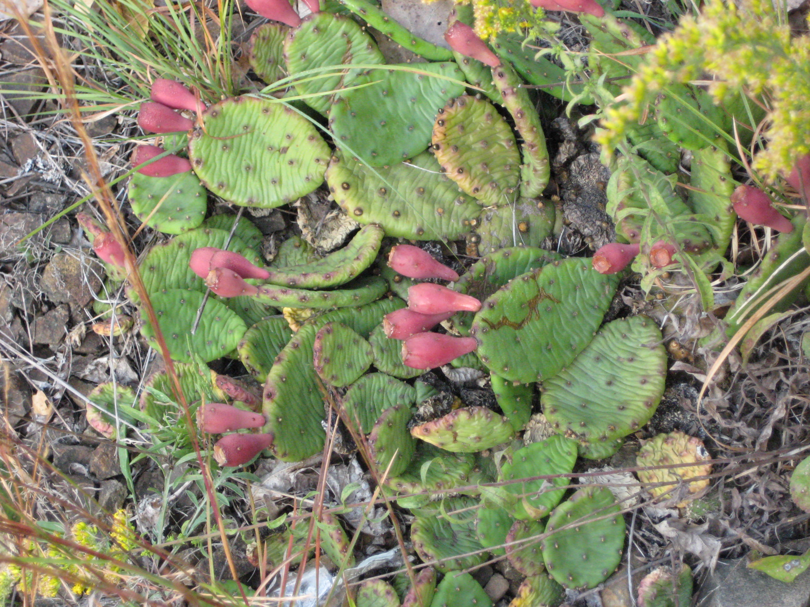
That, my friends, is wild Connecticut Prickly Pear cactus. Something that in my ignorance, I would never have believed unless I saw it with my own eyes. (In fact, I’ve told a few people most of whom simply refuse to believe what is clearly seen in the three pictures above. Since it’s so easy to access, they can go check it out themselves.) Perhaps this offers more of an authority on the matter. It’s okay to be surprised, Hoang and I certainly were.
Hold on – 2018 Steve here. In the 10 years since this was written, the myth of the “naturally occurring cacti in Plainville has been debunked. Mostly in the comments below… I wrapped it all up nicely on a separate page though, because really, cacti growing on an exposed ridge in Plainville is just cool.
The next mile or so of the Metacomet is incredibly fun. It twists and turns; trying its darndest to stay on the closest thing to the ridgeline as possible. That means criss-crossing a Jeep trail about 27 times, which does get a little bit annoying. The Jeep trail of course takes the simplest, flattest route while the trail just swings wildly back and forth to go up and down every little basalt blip possible. At least this allows for some photo ops:

As well as some shots of Hoang looking good chugging up an incline:

Some of the trail blazing was a little absurd, as we could follow the Jeep trail with our eyes the entire time… but we stayed true to our promise of red-lining the entire Metacomet (that is, not missing a step of it) and followed each and every seemingly silly twist and turn. By doing so, we were treated to the first of what would be many overlooks, with views of Plainville, CT below.
Unfortunately, with the accessible Jeep/ATV trails came idiots with cheap beer and a penchant for building fires and littering. This was the first (and most likely last) section of the entire trail that was marred with lots of litter, graffiti, and rutted out tracks. It wasn’t unbearable, but some sites weren’t too pretty either.

As you’ve discerned by now by the date of the hike and looking at the pictures, Autumn had finally come to southern New England. The foliage in 2007 was the worst it’s been in a long, long time. The day of this hike was about a week before typical peak foliage time, and as you can see, it’s pretty weak. That said, it is still beautiful here in the Fall and one of the reasons I really enjoy New England.
After a mile and a half of the winding trail over every little nub, rise, ride, and bump, we reached the site of the former Nike missile launch pad. These things are all over the East coast and there are several others in Connecticut. Here, though, there are no longer any structures or buildings, just a large concrete platform and some fencing. The trail goes right up and over the site.

There is a rock outcropping at the site with nice views west and north. Unfortunately, there is also a rather passable road to this point so there were beer bottles and cans everywhere. I imagine keeping this place clean would be impossible; so I won’t complain about it. Every kid from Plainville or New Britain probably makes it up here at one point or another. The only problem is that some litter marred this otherwise lovely shot:

Note that in the background are two very large TV antennae. One can see these things for miles around central Connecticut and I had known since starting this hike that they were along the trail. They are incredibly tall to say the least.
Things started to get a little weird at this point. As I was trying to figure out how we’d carry out two cases of beer bottles and cans, we heard an engine revving and girls screaming. (It was around 10 AM on a Saturday morning, mind you.) A minute later, I saw three teenage kids running full speed through the woods about 50 yards from our position, silently.

More screaming, more engine sounds, and the three kids had disappeared. I decided to leave the litter and continue north on the trail. As we headed out, I saw a Jeep with a girl spread-eagle on the hood driving up the rutted and rocky road. I didn’t really feel like sticking around to see if that girl chose to be in that position or not… It wasn’t time for me to be a hero.
Just a couple minutes north along the trail we came to Pinnacle Rock. It seems like every trail in America has a rock named Pinnacle Rock, some better than others. Here is the best view from the Metacomet’s:

Yup, there are those TV towers again! They were so close I could taste the electromagneticism. The Metacomet followed the ridge for a short while longer, descended gradually and entered the town of Farmington. We crossed a (relatively) deep little valley area, walked a bit further and stared up at Rattlesnake Cliffs. I’ll admit, they were moderately imposing.
Hoang and I took a little break and discussed building a zipline from the cliffs we had just descended over to the ones we were about to go up and over. You read it here first! (It really would work… sort of like you see in every single Belize tourism film you’ve ever seen.) The Metacomet has a lot of cliffs of basalt along its length and these were among the most impressive.
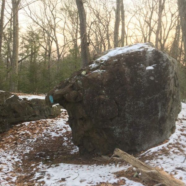
The trail sort of skirts them, but not so much that you lose site of the size of the cliffs. The guidebooks states, “turn left and pass through tunnel/cave formation.” Well, here is what a “tunnel/cave formation” looks like:

I think it looks better looking down upon it. It looks more tunnelly/cavey, don’t you think?

Immediately beyond that cool feature, we passed through a jumble of large boulders (like a Mahoosuc Notch for 5-year-olds. What’s a Mahoosuc Notch? A very difficult section of the Appalachian Trail just over the New Hampshire border in Maine famous – or infamous – for it’s boulder jumble. It’s actually great fun, though sort of stinks with a full pack on. Here’s a little video of it. Cool, huh?”
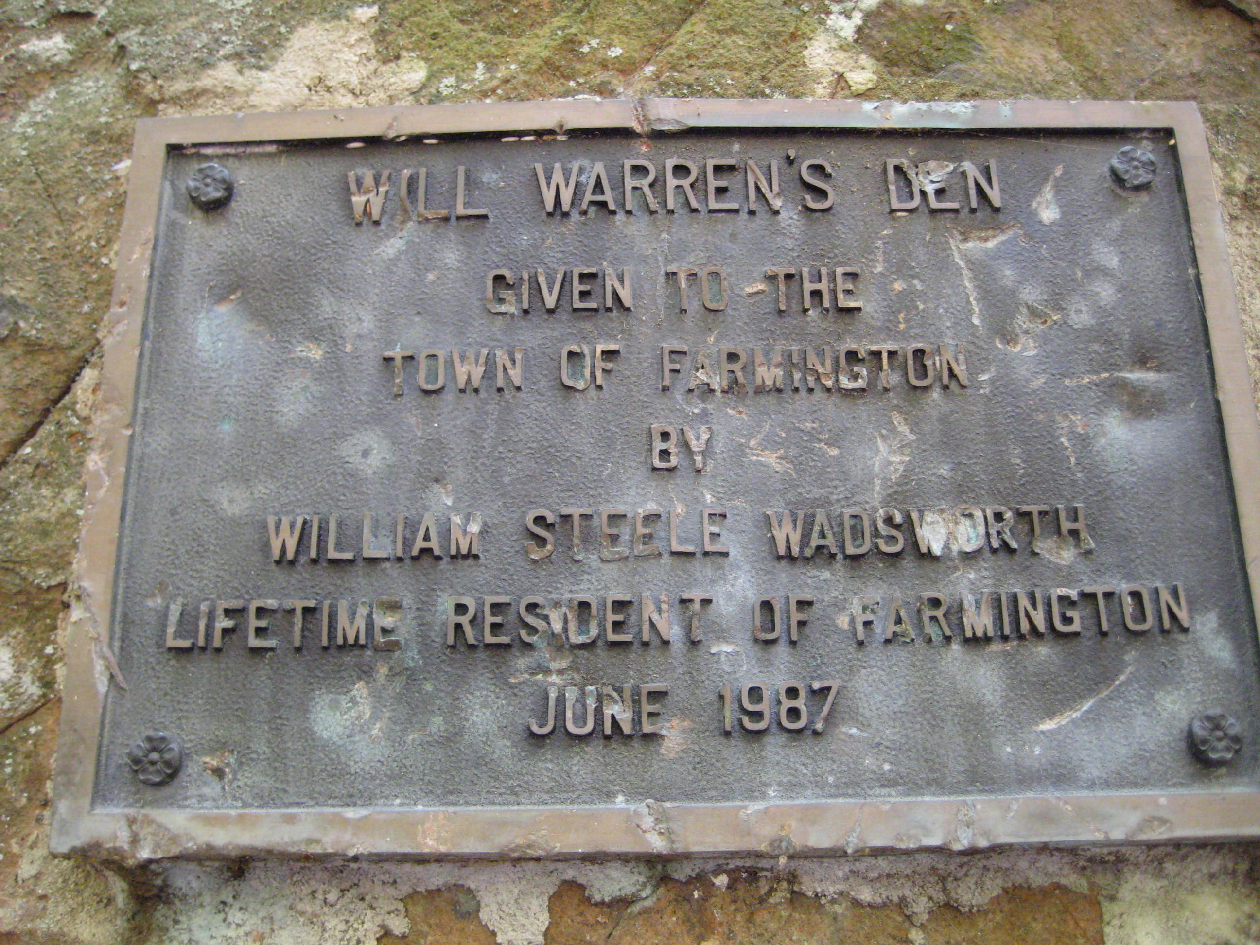
The Metacomet doesn’t offer quite that ruggedness, but it does offer some colorful local history, like Will Warren’s Den and Hospital Rock. After picking our way through a jumble of boulders, we came upon Will Warren’s Den.
Will Warren was a local Farmington scamp back in Colonial days who skipped out on church one Sunday. The town punished him harshly – so he punished them right back. He tried to burn the town down (so they say) and then ran away to the hills. Kindly Native maidens offered him shelter in a little cave – and here it is:

For more on CTMQ’s visit to Will Warren’s Den, Check this out. In the vicinity lies Hospital Rock. It took a couple years after this section hike, but I finally made it out to see Hospital Rock – which is actually nearer the Nike Missile site above than Will Warren’s Den.
From a Hog River Journal article, “Hidden deep in the second-growth hardwood forest of Rattlesnake Mountain is an inconspicuous flat ledge of traprock. On it are carved 66 names of long-ago Farmington residents. This is Farmington ‘s “Hospital Rock,” and it marks the site of Eli Todd and Theodore Wadsworth’s smallpox inoculation hospital of the 1790s. It is a reminder of the terrible epidemics of another day, and of the efforts of local physicians to halt their spread.”
Read all about my visit here.
We reached the summit of Rattlesnake Mountain in short order and thought about the possibility of seeing some actual rattlesnakes. Alas, they are wiped out of this area but I believe there is still a small population of Timber Rattlers over in South Glastonbury. And they definitely still live in the Northwest hills. It is a goal of Hoang’s to see a rattlesnake attacking a bear. Someday it will happen…
Just over the top of the hill, we finally reached the massive antennas. The trail actually passes right underneath the massive support cables and well within the humming steel buildings below the towers. Not the prettiest spot on the trail, but interesting nonetheless. (Two hawks were riding updrafts directly in front of us, so that was certainly pretty.)
The descent was cake… apple cake to be exact. A nice contoured path took us through an old, abandoned orchard. The smell of apples was overpowering and really pretty nice. The trail was easy and we thought about collecting the fruit to make a “Metacomet Apple Crisp,” in Hoang’s words.

We crossed Route 6, which I only mention because it’s a pretty bad road crossing. Only two lanes, but a hilly bend just above the trail calls for running across the road. We survived. The trail passes near Farmington Reservoir… I knew we were approaching the cul-de-sac of Poplar Hill Road – home of mega millionaire hip hop star, Curtis Jackson, aka 50 Cent.
2017 Re-route
(Dawn hike on January 20, 2018)
Let’s back up for a second… back out to the route 6 crossing. From the road, the trail climbs quickly and looks down upon a cistern. This is not exciting, as it simply looks like a concrete rectangle.

(Because it is just a concrete rectangle from above.)
The trail picks its way along the top of a cliff above the Farmington Reservoir. This is a pretty nice little stretch and affords some decent views of the reservoir and west. Although, after the previous views on this section, they’re really not all that exciting.

In Farmington’s town literature, they really play it up though – likely because it’s one of the best views in Farmington.

A large boulder stands sentry above the reservoir. This boulder is known as Reservoir Rock according to the Farmington Land Trust. It has always reminded me of an elephant shrew. I’ve passed it several times in my life and yup, it should be called Elephant Shrew Rock.
The Farmington open space folks include this stretch of the Metacomet as part of their “Reservoir Trails” and make the notation to turn around at Reservoir/Elephant Shrew Rock:
Retrace your steps, since the blue trail continues north to Massachusetts.

That cracked me up. Imagine being so dopey that you pass the rock and continue north for 30 miles into Massachusetts. (I walked around the Reservoir Trails, of course, and gave them their own page here.)
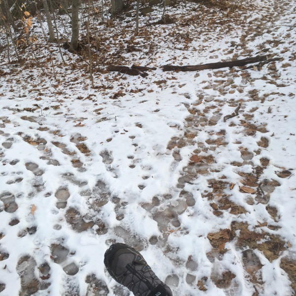
The 2017 reroute begins shortly past the rock. The old trail still exists, and judging by the tracks in the snow, it is still hiked. I’m guessing the wealthy folks from Poplar Drive use it for dog walking and such.
The new trail veers left and follows a woods road for a bit, and heads down towards a property with two large, very loud dogs. They never came within 50-feet of me, so don’t be as nervous about them as I was.
The new trail passes below a massive cliff that rises up to a mansion’s backyard. The Metacomet passes beneath and walks above a billion of these things, but I never tire of them. Figuratively anyway.

This change to the Metacomet’s route is very short, but fairly significant. No longtime or long-distance hiker likes road walks, so organizations like the CFPA do their best to avoid them. The CFPA trailwork is always exemplary –


In this case, that meant gaining clearance to shift the trail from Poplar Hill Drive just northwest of it into the woods. Here’s the shift:

Like I said, not a big reroute, but… it used to literally pass in front of one of the most notorious slash famous slash infamous mansions in the entire country. And now it doesn’t. And for some reason, that sort of makes me sad. (I’ve noticed that Poplar Hill has been extended and now there are a bunch of new McMansions up there… perhaps necessitating the reroute more than anything.

I picked my way over the trail out to Mountain Road across the icy trail. I don’t really recommend hiking across basalt talus in snow and ice. It’s not that I thought I was in danger, it’s more than traversing such things is not the easiest way to get from point A to point B.

After crossing Mountain Road, I’m happy to report that the trail still goes up someone’s driveway as in the past. I love this quirk for some reason. Past their compost bins and back into the woods.


I believe I heard mention that the homeowner is a friend of the CFPA, and my original 2007 report contained the following:
An older man was out doing yardwork and gave me a hearty wave and smile – something I’d guess he’s been doing to Metacomet Hikers for years. His old Irish Setter bounded towards us and I felt like we were in an Alpo commercial.
I skirted a couple more properties with massive houses and quickly found myself nearing route 4 and the end of the section.

It is here that the Hill-Stead Museum’s trails intersect with the mighty Metacomet. I detoured and checked them out before heading out to the busy and dangerous road crossing at route 4.
Yup, just as sketchy as ever… you must have your wits about you here – probably the most dangerous 100 yards of the entire New England Trail in Connecticut. And I don’t say that lightly.
Ah, I feel better now that I’ve completed the reroute of this section. Back to 2007 and warmer weather…

While not quite a highway, Farmington’s Route 4 is a traffic nightmare. If feeds several towns to the Interstate and the bottleneck caused by the 10 lane i-84 highway to the two lane Route 4 is just a mess every single day. The Metacomet Trail crosses this mess right where the magic happens; first a jughandle… check. Then a pleasant grassy area and finally the 4 lanes (in between the 10 and the 2). We waited a good five minutes before a safe break appeared; we made a run for it and lived.

Almost done for the day, we walked along some fencing and a gas line and quickly hit Prattling Pond Road. Our car was spotted across Farmington Avenue at a Park and Ride and that was it for the day. Wow… what a crazy 6 miles. I love this trail!

![]()
Continue on to Section 9: Weather Or Not, We Hike